Park Trails & Map
Download Our Park Map
Before you hit the trails, make sure you have everything you need for a seamless adventure. Download the official park map to explore key points of interest, scenic trails, parking areas, picnic spots, and more. Whether you're hiking, biking, or just enjoying a peaceful walk, this map will guide you every step of the way. Stay on track, discover hidden gems, and make the most of your visit—grab your map now!
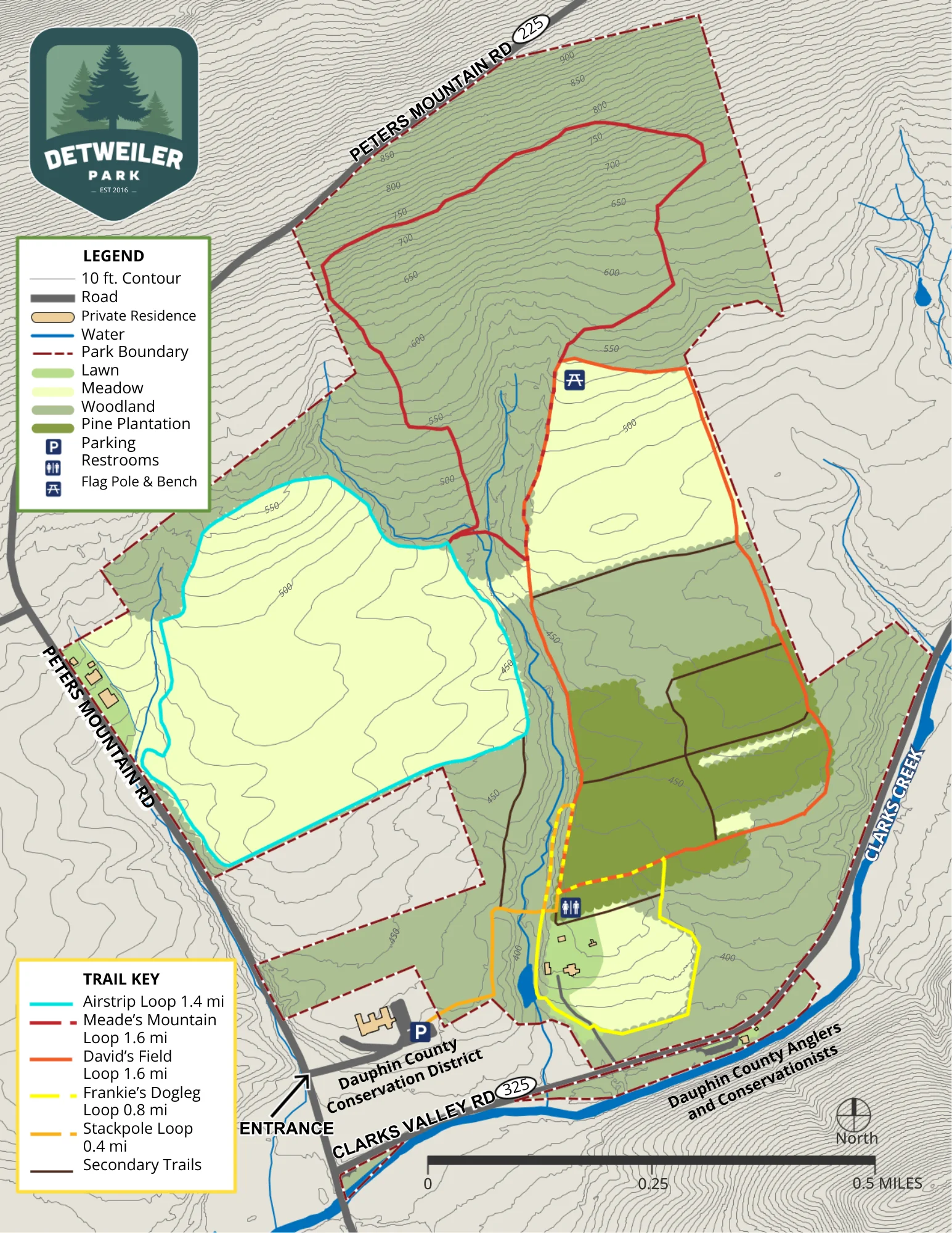
Detweiler Park Walking & Hiking Trails
- Distance: 0.4 miles
- Difficulty: Moderate
- Surface: Unimproved, Soil
- ADA Accessible: No
The Stackpole Trail, also referred to as the “main trail”, begins at the trailhead parking area and crosses the creek on a bridge. It connects to other trails and has a spur leading to the Airstrip Loop. A restroom is located at the east end where it joins David’s Field Loop and Frankie’s Dogleg Loop.
- Distance: 1.4 miles
- Difficulty: Easy
- Surface: Unimproved, Soil
- ADA Accessible: No
- Blazes: Blue
The Airstrip Loop encircles a beautiful meadow that once served as an airfield. Look for common milkweed along with a variety of meadow songbirds and insects along the trail. There are two access points to this trail. One is from the Mountain Loop along the east side of the field; a second is a spur from the Stackpole Trail in the southeast corner of the field.
- Distance: 1.6 miles
- Difficulty: Most Difficult
- Surface: Unimproved, Soil, Rocks
- ADA Accessible: No
- Blazes: Red
Etched into the side of Peter’s Mountain, Meade’s Mountain Loop has an elevation change of around 500 feet. Rest in Adirondak chairs after the climb and look for groves of pawpaw trees along the eastern side of the trail. Exposed rocks and wet areas create a challenging hike. There are two access points to this trail: on the west from the Airstrip Loop and on the east from David’s Field Loop.
- Distance: 1.6 miles
- Difficulty: Easy
- Surface: Unimproved, Soil
- ADA Accessible: No
- Blazes: Orange
David’s Field Loop encircles the east field with its panoramic views and a forest with diverse trees including white pine and sassafras. Look for deer in the field and a variety of wildlife from red squirrels to pileated woodpeckers in the forest. Many exposed tree roots pose tripping hazards. It connects to the Stackpole Trail, Meade’s Mountain Loop, and Frankie’s Dogleg Loop.
- Distance: 0.8 miles
- Difficulty: Moderate
- Surface: Unimproved, Soil
- ADA Accessible: No
- Blazes: Yellow
The Dogleg Loop circles the old Detweiler residence. Various songbirds can be heard in the meadow and stream habitats and American holly grows along the south side of the loop. The southeast section of the trail holds water from springs making this area very wet for the majority of the year. It meets the Stackpole Trail near the bridge and joins the southwest corner of David’s Field Loop.
- Distance: Varies
- Difficulty: Easy
- Surface: Unimproved, Soil
- ADA Accessible: No
- Blazes: Brown
Secondary trails of various lengths run through David’s Field Loop. Discover a small stand of larch trees and explore the secret meadow. Many exposed tree roots pose tripping hazards.

Park Rules

Volunteer
